Saturday, October 23, 2010

2010 Fall Trip--10/22 Homeward Bound


The plan was to head south to Flagstaff or Cottonwood and find a campground for the night. We left Moab at about 7:15 AM in a light rain which slowed us down a bit since we were going through the mountains. Then about two hours later we ran into a convoy of huge mining equipment and we spent several miles going 30 mph. When we finally reached Flagstaff it was still raining, very dark clouds, and 41 degree's. I thought it would start snowing any minute. The Cottonwood area wasn't much better so we kept truckin' on down the mountain. We finally found the sun again just north of Phoenix and then got stuck in Friday afternoon rush hour traffic. At that point it didn't make much sense to stay overnight at a campground since we were only 2 hours away from home. We made it back to Green Valley about 8:30 PM. After 605 miles in one day Betsy and Tipper tell me that on future trips there will be new rules about how many hours one may drive in a single day.

Next week I'm driving back to NE Arizona to meet Cousin John and friend Larry from Denver and explore Canyon de Chelly. Can't wait!!

Top Photo--sandstone formation called Elephants Feet just north of Tuba City, AZ. Can't you just hear the old prospectors arguing, "dang-na-bit Clem them thar things don't look nuthin' like tree stumps. They look like elephants feet."
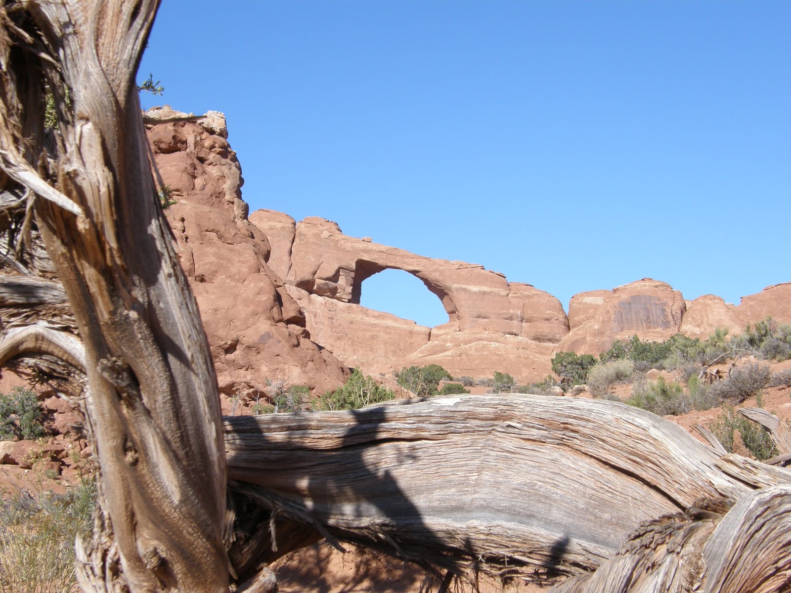
Middle Photo--Arches National Park
Bottom Photo--Balanced Rock, Arches National Park

2010 Fall Trip--10/21 Canyonlands National Park


In addition to Arches National Park there are several other national or state parks close to Moab.
We chose for our last day the Islands In The Sky section of Canyonlands National Park. I'd never heard of this park until a few months ago, but we learned that it was set aside as a park back in the 60's. It's about 35 miles from Moab and was much less crowded. We may have saved the best for last. All I can say is WOW!! We will remember this trip for a long, long time.
Top Photo--Mesa Arch
Middle Photo--Bucks Canyon
Bottom Photo--Schaefer Canyon They used to drive cattle up and down this road to get them to the summer and winter pastures. Then when uranium was discovered they drove loaded trucks up and down!

2010 Fall Trip--10/20 Arches National Park


After two nights in Bluff, UT it was time to move on. Our next destination was Moab, UT and Arches National Park. Getting to Moab was a short drive of 2 hours north. After checking in at our campground we headed to Arches. I'm sure you've all seen pictures of the many natural arches formed by eon's of wind and water erosion so I'll only publish one here. We found an off road vantage point of an arch that Betsy wanted to sketch. While she did that I took a trail that went up a huge formation of rock. When I got to the top I found that I wasn't alone. There was a raven sitting on a rock next to a small cairn that someone had left. At first I thought the raven was injured since I could get quite close, but he would hop around and then fly to a different location but never really left. I would make a kissing sound and it would look at me and then make a response noise. Of course all this time I was taking pictures like mad. What a great treat.

2010 Fall Trip--10/19 Monument Valley II


Yesterday when we were in Monument Valley we had Starship Avion with us so our movement was limited to the parking lot. We wanted to return and drive the 17 mile loop road in the valley. So we headed back to Monument Valley and then later in the day we went through an area called Valley of the Gods. I have never seen such spectacular scenery!!

2010 Fall Trip--10/19 Bluff, UT


After our visit to Monument Valley yesterday we headed toward Bluff, UT where we had a campground reservation. Bluff is aptly named as it is truly surrounded by towering sandstone bluffs. There are 4 or 5 big old houses that are made out of sandstone blocks. According to one local the big houses were built back around the early 1900's by area ranchers. Bluff is very small but has some interesting businesses.
The Dairy Cafe is indeed a local eatery but has an extensive array of Native American jewelry. According to the owner, the artists bring the items in and they (the artist) put the prices on them. Several of the business use old trucks as a means of getting attention.

Monday, October 18, 2010

2010 Fall Trip--10/18 Monument Valley


I'm not going to do a lot of writing about our day today. Words just can't describe the beauty we saw today. (If you click on any of the pictures they will show as enlarged on your computer)

Sunday, October 17, 2010

2010 Fall Trip--10/17 GV to Flagstaff


Ever since we arrived home from our last trip through NM and CO I've been looking forward to our current trip to Monument Valley and then into the never visited (for us) state of Utah. I guess it's all those old western movies that I watched as a kid that hooked me on the mystic of Monument Valley.
We left Green Valley this AM with Starship Avion in tow and Tipper in the back seat. For once, we got through Phoenix without any problems, however it was Sunday. Usually we seem to hit Phoenix at rush hour. One of the things I love about AZ is that we started in a low desert area (elevation 1800 ft), actually went lower when in Phoenix and then started climbing toward Flagstaff which is over 7000 feet in elevation and in a sub-alpine climatic zone. We have marveled at the Ponderosa Pine and actual hardwood tree's. Such a difference from what we're used to. We are somewhat familiar with Flagstaff, as son Jeff graduated from Northern Arizona University for his undergraduate degree.
I've always liked the story of how Flagstaff got it's name. Back in 1876 a group of pioneers were passing through and on July 4th they camped at a spring in the shadow of the San Francisco Peaks. To celebrate the centennial, they stripped the limbs of a large pine tree and hoisted up Old Glory. The flag staff stood for years and was known as a meeting place. When the town was settled it was decided to call the area what it had been called for years--Flagstaff. The first family of Flagstaff are the Babbits. In 1886 four Babbit brothers gave up the grocery business in Cincinnati, hopped on a train, and landed in Flagstaff. They came west to start a cattle ranch, which they did, however things were not going well on the ranch and their backer suggested that they try a business that they knew something about. They had a sandstone building erected and once again went into the grocery business. That business flourished and they soon expanded into hardware, saddles and harness and other ranch goods, and even operated several trading posts in northeast Arizona. And that cattle ranch?? Well, they managed to hang on to it and finally it prospered. It's still in the Babbit family and they continue to ranch without the assistance of modern machinery. And the original store is still in business. Many of you will remember that Bruce Babbit was govenor of Arizona from 1978 to 1987 and then served as Secretary of the Interior from 1993 to 2001. Quite a story.
We walked around in town, drove the Route 66 portion, and then headed back to the RV park. According to the radio the low temp tonight will be below 40 degree's! Earlier this evening we had a cold rain, but being a desert dweller now I have a new appreciation of rain. New territory tomorrow!!
Top Photo--Home Sweet Home with leaf's.
Bottom Photo--Babbit Brothers store
jmk

Monday, July 19, 2010

July 13, 2010 Old Fall River Rd, RMNP


Our trip today will be on the Old Fall River Road which was the first road through the park. It was started in 1913 and completed in 1920. It is only 9 miles but in that distance you travel from woodland through sub alpine to alpine tundra climatic zones. The road today is very much like it was years ago, except that it is one way today. I'm sure there were many tense moments when cars were allowed to travel both ways. Once you reach the summit and the Alpine Visitors Center you use the newer Trail Ridge Road to descend. I had thought that the trip might take 3 hours, but in actuality it took 7. We couldn't resist all the photo op's.
Top Photo--Bull Elk just below Alpine Visitors Center
Middle Photo--At about the half way point we had stopped to take pictures and up rolls a taxi. Photo also gives you a little glimpse of the actual road.
Bottom Photo--Just one of many spectacular views.

July 12th, 2010


We're finally at our destination just outside Estes Park, CO. Our friends Kay and Ernie's son in laws family has owned cabins up here for years. At one point some of them were rented to the summer help in the national park or shops in Estes Park or just vacationers. Several years ago one of the cabins burned so a vacant space exists and that's where Starship Avion has landed. In addition to Kay and Ernie another couple from Columbus have joined us. At one time we all lived in Columbus so it was fun to catch up on the happenings. Our camp is about 3 miles from Estes Park which is a total tourist town. There are the tee shirt shops, jewelry stores, candy and ice cream shops, etc, etc. You've been "there" I'm sure. Just outside town is Rocky Mountain National Park. Yes, the park is crowded now, but you know what, every once in a while you will look at a towering peak or a mountain meadow and the thought hits you "This is what it looked like 200 years ago when an Indian, mountain man, or trapper looked at the same sight". What a thrill.
Top Photo--Starship Avion at rest.
Bottom Photo--The Estes Park Gang.

Thursday, July 15, 2010

July 6th through July 11th, 2010


On the 6th we loaded up and headed down the mountain. I am a certified flatlander when it comes to pulling a trailer, but I must admit I am getting better and more confident in going up and down these mountain roads. We went from our campground through Colorado Springs, caught I-25 north and headed towards Estes Park where our old Columbus, IN friends were staying in their son-in-laws cabins.
After arriving we parked Starship Avion, stayed overnight, but then headed back to Denver to stay and visit with cousin John. I know this doesn't make any sense but it was a timing thing. While in Denver we went to several antique or thrift stores, had a lot of good food, and just had a good time being with nice people. The 11th we headed back to Estes Park to await the arrival of more old friends from Columbus, IN.
Photo's--Hike pictures at Redstone Rec Area just south of Littleton.

July 5th, 2010 Victor (revisited) & Cripple Creek


We awoke to hail on the ground! Just after we returned to the trailer last night the storm caught up with us. You can imagine what a hail storm sounds like in an aluminum trailer. I really thought we would have visible damage, but we had nothing. We returned to Mueller S P and had a great breakfast with the Denver group. I simply do not understand why these people don't weigh 300 pounds apiece. We said a sad farewell to the group as they had to pack up and return home. We decided to stay an extra day.
We headed toward Victor, but before getting there we took a little side trip on Gold Camp Road. We checked out a couple of places in Victor and then headed toward Cripple Creek. While Victor is an almost ghost town Cripple Creek has elected to revive itself by gambling revenue. We were totally uninterested in Cripple Creek downtown and elected to drive through an old residential portion of town. While there we saw burro's resting alongside a home. We then remembered that Cripple Creek is the town that allows the descendants of the mine burro's to roam free. There is a group of people in town who provide feed and care of the animals. With the exception of the burro's we found nothing else that interested us in Cripple Creek, but have tucked Victor into the back of our brains as a possible future summer resting place.
Top Photo--Gold Camp Road
Middle Photo--Burro's of Cripple Creek, CO
Bottom Photo--Hail on the ground on July 5th

July 3rd & 4th, 2010 Victor & Mueller State Park, CO


Early on the 3rd, J & E and L & S picked us up and off we went to the old gold mines around Victor, CO. This area between Victor and Cripple Creek had some of the most productive gold mines in the U. S. Many of the buildings are still there and available for exploring. Our next stop was Victor, CO which some say is one step above a ghost town, but it did have permanent residents and a downtown. In reading about Victor two things stick out--in the late 1890's a couple were
having a spat and one threw a coal oil lamp at the other. The resulting fire burned down the east side of town. A few days later a pan with grease in the hotel kitchen caught fire and that fire burned down the west side of town. Consequently, all of the downtown buildings date from around 1899 to 1903. The second item about Victor is that when the town decided to build a new courthouse they started digging the foundation and struck gold!! Boy, those people in Victor had all the bad luck. We met up with J & K
and had lunch in Victor, then headed back to Mueller State Park for a wonderful dinner with the Denver crowd.

July 4th started out bright and beautiful. Betsy and I drove over to Mueller S P to meet up with the Denver group. We just hung around camp and talked mostly. Later in the day we started preparing dinner and noticed that large black clouds were moving into the area. Just as we were finishing dinner the sky opened and it poured. Luckily we were under a 10 x 10 canopy, but eventually the rain became to heavy and we sought shelter in L & S fifth wheel. We had eight people and five dogs in there, but the unit was big enough to shelter us all. We were all talking when all of a sudden we realized that it was hailing!! The hail peppered down and there was some concern that it would accumulate and collapse the awning on the RV, but the awning was retracted without damage. Betsy, Tipper, and I waited until the rain and hail paused and then we took off, up the mountain to our campground. The temperature fell to 46 degrees, and hail covered the road for some of the trip but we went slow and made it home safely.
Top Photo--I'm not sure how this all transpired, but I walked out of a shop and the Denver Circle had somehow gotten involved in a tomahawk throwing lesson. I've always wanted to try my luck at it so I jumped right in. Managed to stick 1 out of 3.
Bottom Photo--downtown Victor, Co.

Monday, July 5, 2010

July 2nd, 2010 Cripple Creek, CO


When we planned this trip we thought we would be in Estes Park for the holiday weekend but it didn't work out that way. I called my cousin in Denver and ask if we could hang out with them and their friends over the holiday. Since they all have RV's they make a point of camping out on the holiday weekends and others. The problem was that the state park they were camping in is extremely popular and reservations are made months in advance and at that point the campground was full. However there was a private campground about nine miles from the state park so we got reservations there.
What we didn't know was that the nine miles was mostly straight up. Our campground is one of three in the U.S. over 10,000 feet in elevation! But the view is great. Both Betsy and I think that this is probably the best view of all the campgrounds we've ever stayed. After settling in, we headed over to the park to meet up with "our Colorado friends". They have been friends for years and since my cousin and his wife are in the group they have graciously allowed us to join them in their travels. I'm pretty sure that Betsy and I are on probation status at this point, but we haven't been kicked out yet. With Betsy and I the group consists of four couples with a total of five dogs. What a sight we are when we move about. They are really a fun group.
Top Photo--Starship Avion in the mountains.
Bottom Photo--Local Wildlife

July 1st, 2010 Northern NM & Southern CO

Today was one of those days spent on the interstate system getting from point A to B. It was about 225 miles but the new vehicle pulling the trailer is not as "comfortable" pulling as the truck was. Maybe I'll get used to it one of these days. We flew up I-25 to Trinidad, CO and Trinidad Lake State Park. Our campground directory said that we should use exit 14B off of the interstate. We passed up exit 14 thinking that the next one would be exit 14B. To our surprize the next exit was 13A, with no mention of the state park. So we went north another exit, and turned around for another crack at finding the correct exit. This time, as we headed south, we saw a sign saying that the state park was actually exit 13B. Yeah, we found it! Well, not so fast. When we approached we saw construction and a sign saying that commercial trucks should not use the exit due to tight turns. So we continued south and found an unobstructed exit to use and headed north again for attempt number 3. At this point the old Kingston
Trio song called MTA (Metropolitan Transit Authority) was playing in my head. It was a song about poor old Charley who didn't have a nickel and therefore couldn't get off of the train. We did finally find the correct exit off of the interstate only to find that most of Trinidad was under road construction too. Somehow we found our way through the maze and caught the road to the state park. We wanted to spend some time in Trinidad because it is a neat little town, but by the time we arrived at the park we were exhausted. We pulled into our spot, didn't even unhook, did some laundry, took showers, ate, and went to bed. Another exciting day on the road.

June 29, 30th Ojo Caliente, Santa Fe, Taos


Our next stop was Ojo Caliente, NM which is a tiny town between Santa Fe and Taos. Ojo Caliente Resort is located there and has hot springs and pools. Betsy and I were not interested in the springs and pools but we decided to stay in their campground just for the convient location to both Santa Fe and Taos. We visited Santa Fe first and found it to be pretty much like it was when we visited several years ago. We did have a little scare while there. We used the St. Francis hotel patio to get our bearings and then headed off to see the sights. We stopped at a gallery about three blocks from the hotel and Betsy realized that she had left her purse on the patio. We rushed back and the purse was gone. However some dear soul had taken it to the hotel desk. Thank you, whoever you are. We looked in several stores, found the old plaza where the Indian blanket traders sell their jewelry, and enjoyed ourselves very much. The next day we reversed direction and headed north to Taos. Taos is smaller than Santa Fe but the old plaza is very similiar. It has galleries, tourist shops, cafe's. Betsy visited the Nicholi Fechin museum. As mentioned on the last post, antique stores will let Tipper come in, but museums won't. Tipper and I waited in the car. For some dumb reason I was having a sinus meltdown that day and didn't really feel well so we didn't do the pueblo. However we did return to Ojo Caliente a different route which took us over the Royal Gorge on US 64. The gorge is this steep canyon, created by water erosion, with the highway bridge over it. We stopped by the side of the road and started to walk to the middle of the bridge, but Betsy turned back when she felt the bridge move as traffic went over it. I made it to the middle, took a few pictures and retreated as fast as possible to terra firma.
Top Photo--Royal Gorge. That's the river way down there.
Middle--Camel Rock outside Santa Fe.
Bottom--Taos flower cart.

June 27 & 28 Albuquerque


We have always pretty much considered Albuquerque somewhere to "get thru", but this time we've decided to explore a little bit since we have time. Enchanted Trails RV park is very close to Route 66 and have a ton of info about the sights in Albuquerque. I learned that the original Route 66 thru town was not an east- west route but rather a north-south highway. I believe that was the case until something like 1937 when it was re-routed. The north-south original highway is basically 4th street now. We took the time to drive it and saw several of the old Route 66 survivor gas stations, motels, and tourists courts. The east west route is now Central Ave and it too has several old buildings. We did a typical tourist thing and visited Old Town where all the shops are located. What we discovered was that if you venture into the small streets, and alley's you will find some real neat merchandise as opposed to the tourist junk on the main streets. We also found the "antique mile" and visited some shops. The first one we stopped in was run by a very nice, funny, older couple that we really enjoyed talking to. We found items for both Cuz John and wife Elaine. We always ask if Tipper can come in to the antique shops and almost every time he's been allowed in. He's a very good shopper. Almost as good as Betsy!
Top Photo--Old neon sign. Very cool.
Middle--New Mexico must be the place to grow Hollyhocks. We see them everywhere.
Bottom Photo--2nd story trailer. You don't see this very often.

Saturday, June 26, 2010

June 26, 2010 Silver City to Albuquerque


Today was a travel day, but we still managed to find something new and different. We headed out of Silver City headed for northbound I-25 but to get there we first had to go 54 miles SE and then another 50 miles NE.
After what seemed like backtracking for an hour or so we finally arrived in Hatch, NM on I-25. Hatch boasts that it is the Chili Pepper Capital of the World and if they say so it must be true. Cousin John told me that there is a quirky little hamburger stand called Sparky's in Hatch. Sparky's speciality is the world famous green chili cheeseburger. While it was only 10:30 AM we couldn't forgo the opportunity to taste one of these treats. Betsy really liked hers. I liked mine until the green chili's kicked in. Whew!! We had to eat outside because of Tipper but the waitress came out and ask if she could bring him a treat. We said sure, and thought she would return with a doggie biscuit. Well, she returned with a bowl of pulled pork and she sat down and fed Tippy!! Now that's service.
The trip up I-25 was uneventful and we arrived at Enchanted Trails RV Park just in time for a rain squall.
Enchanted Trails is a "vintage friendly" RV park. They even have four vintage trailers that you can rent for the night. Cool.
Photo 1 Sparky's, Hatch, NM
Photo 2 Touch of class inside Sparky's
Photo 3 Hudson Super Six
Photo 4 Hudson Hornet

Friday, June 25, 2010

June 25, 2010 Pinos Altos, NM


Just six miles from Silver City is another mining town called Pinos Altos (Tall Pines). It's higher up in the mountains but much smaller in population. A group of forty-niners drifting home from CA discovered gold in Bear Creek and before you knew it a town had sprung up. When the gold was plentiful the population was around ten thousand but it's dwindled down to less than a thousand hardy souls. The buildings are somewhat ramshackle, a majority of the population appears to be in the geriatric hippie category. But you have to give the old town some credit as it's hanging in there. I wonder why many of the old mining towns seem to attract the hippie element? Actually I think I could be right in there with them, except Betsy has standards. We stopped at the community art gallery and we bought a small painting and it's found a place on the trailer bulkhead. We also found the US Post Office, ice cream parlor, small cafe, antique and collectible store. All of those enterprises were all in the same building. We had an ice cream cone, Betsy wrote post cards, Tipper presented himself to all the patrons in hopes of being petted, and I sat there and tried to remember the words to The Age of Aquarius. We also saw a great bumper sticker. A great afternoon in Pinos Altos.

June 24, 2010 Green Valley to Silver City, NM


Well gang, as promised we are back on the road. Get the women and children out of the streets!! It's been almost seven months since we've had any long term trailer livin'. We arrived in Silver City, NM at about noon, found ye old trailer park, unhooked, set up, ate lunch, and immediately got back into the SUV and headed for downtown. Silver City is an old mining town at 5900 feet above sea level, home to Billy The Kid, and Billy Casper who was a professional golfer years ago. We wanted to visit because it's known as an artist community with a couple of good antique stores. Another draw was the downtown architecture. Shortly after Silver City was founded the city fathers had the good sense to enact a building code that said all commercial buildings had to be build from adobe or brick. They avoided the catastrophic fires that plagued many other western towns. Consequently the downtown section is perfectly preserved. Many of the buildings are decorated in the art deco style, others are brightly colored. Our biggest treat of the day came from nature. On the drive over we commented several times on the beautiful cumulus clouds and that we could actually feel humidity. At dusk we were treated to a thunderstorm. We tried to remember the last time we had been rained upon and decided it was probably back in early April.

June 25,2010 After the rain last evening, we awoke to a perfectly clear blue sky and bright sunshine. Yes it supposed to be almost 90 degrees, but that beats the 109 that we left in Green Valley. In our travel brochures we found something that intrigues us. It's called City of Rocks and is located about 30 miles south of Silver City. It's not really a city with buildings but a grouping of huge boulders in an otherwise rock free landscape. The amazing thing is the theory on how the boulders got there. According to geologists a volcano erupted about 33 million years ago and threw these boulders to their present site. The volcano was located near the Albuquerque which is almost 200 miles away!!! The site is now a state park with a small campground for trailers, but there are also several tent camping sites located right next to the rocks. Some of them are very cool. This would be a good place to bring the whole family and camp for a few days.